


New Crete floodplain map effective Oct. 27
 Launch the media gallery 1 player
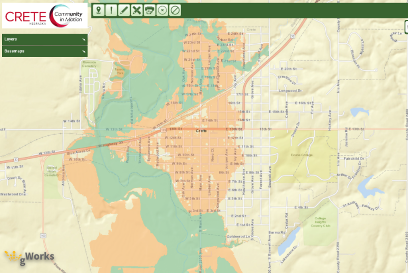
New map eliminates majority of residential floodplain properties
A new FEMA floodplain map for the City of Crete took effect on Oct. 27 after several years of study and process delays. The new map eliminates a very large portion of properties from the floodplain, including nearly all residential properties aside from several blocks along Main Ave in the north part of town.
The proposed, redrawn floodplain map was submitted to the Federal Emergency Management Agency in the fall of 2019 after a study by Olsson Associates utilized new, 2018 river flow data. After delays during the height of the COVID-19 pandemic, it was finally approved and sent back to the city for implementation.
The initial engineer’s study cost the city about $49,000, but its outcome removed about 350-400 properties from the 100-year floodplain designation. City officials are anxious to see the potential benefits of this flood plain change, primarily the increase in property values in previously floodplain designated areas.
(View the new floodplain map on the city's gworks site - select 'Floodplain' under the Layers tab at left.)
Properties set to be removed from the floodplain, which before required costly flood insurance, will no longer have that added expense, boosting resale potential, as well as giving owners the opportunity to improve their properties without a 50 percent restriction.
Officials also see the opportunity to use redevelopment methods for new, in-fill housing on lots previously deemed unbuildable due to floodplain restrictions and requirements.
Federal buyout program
Areas remaining in the floodplain on the redrawn map include 16 residential properties on Main Ave. from 18th to 20th streets.
A federally regulated hazard mitigation buyout program was a way for the city to remove nearly every inhabitable property out of the floodplain without condemning any properties or using other means.
The city notified property owners in the two block area on Main Ave. in 2019, outlining a voluntary buyout program where the city would purchase the property at fair market value using grant funds. Six property owners voluntarily opted into the buyout program and were also offered relocation assistance as outlined in federal law.
Buildings on the six properties acquired by the city are either being relocated or demolished and the lots turned into park space. The city council voted Nov. 1, 2022 on a contract with Brandt Excavating for demolition and removal of the six hazard mitigation properties.
Regulations for existing floodplain properties
Currently, any property in the floodplain must follow all FEMA requirements related to improvements, which are also outlined in Crete City Code and enforced by the Municipal Building Inspector. A property in the floodplain cannot be updated or improved by more than 50 percent of its value and must have all required floodplain development permits for such work. Flood plain properties with loans also pay for expensive flood insurance. (See Building and Zoning information.)
Floodplain study timeline
Olsson was already working on the study when flooding affected parts of the state, including Crete, in March 2019. The Big Blue River at Crete experienced a historic high of 30.68 feet on March 15 of that year, surpassing the old record of 29.86 feet set in July 1986. Even with the record river level, Crete neighborhoods on the west side of town experienced minimal, significant property damage due to rising flood waters.
Find more information: